New Model Sheds Light on How Wildfires Spread Through Communities

Insights could lead to more effective mitigation that saves lives and property
California has already recorded more than 6,000 wildfires this year, underscoring the need for better mitigation strategies to reduce their devastating impact. Now, researchers have created a model that may shed light on how these fires spread through communities in the wildland-urban interface (WUI), enabling us to better assess the risks of wildfire and take steps to build more resilient communities.
In a study recently published in the Proceedings of the Combustion Institute, a team of researchers led by Michael Gollner, professor of mechanical engineering, demonstrated how this new model simulates wildfires as they propagate through communities. By reconstructing two past large wildfires, they were able to extract data that describes fire behavior, gaining insights into how embers, wildfire flames and urban structures together contribute to fire spread and destruction.
“With this model, we’re not just reconstructing a fire; we’re learning more about the process by which fire destroyed these communities,” said Gollner. “We’re also able to use the model to see what mitigation strategies could be effective at protecting communities in the future.”
A holistic view of wildfire and urban landscape interaction
The researchers’ 2D model is the first of its kind to fully integrate wildland and urban fire spread processes. By visualizing the hopscotch-like interplay between wildfires and urban landscapes, it captures the complex dynamics of WUI fires and offers insight into the primary mechanisms for fire spread.
In developing their model, the researchers set out to fill a major gap in current modeling tools used to assess risk. “Every community and every structure are literally labeled as non-burnable in today’s wildfire models. And that’s what we sought to change,” said Gollner. “To get a more accurate risk assessment, we needed to introduce data to quantify wildfire risk to structures.”
Such data includes structural attributes, like construction materials and surrounding vegetation, as well as the fire intensity of approaching flames. While structural attributes determine susceptibility, fire intensity and embers represent exposure from fire and, together, their capacity to ignite structures. “Integrating these factors allows for estimating structural damage, considering both variability in attributes and approaching flames’ strength,” said Gollner.
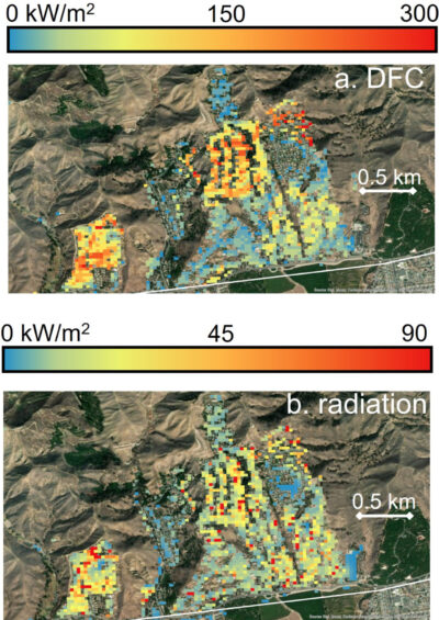
In addition, the researchers designed their model to comprehensively address the three primary pathways for WUI fires to spread into the community: direct flame contact, when structures ignite through direct contact with flames from an approaching wildland fire; radiation, the intense heat emitted by flames that increases the temperature of combustible materials on or within a structure; and firebrand ignition, when flammable vegetation or structural materials break off and travel ahead of the advancing fire, as seen with embers.
They then seamlessly integrated their WUI model with ELMFIRE, an existing tool that simulates wildland fire spread and is used by power companies and counties across the state for risk assessment. This integration made it possible to model the process of wildfires spreading into the urban communities.
Learning from past wildfires
To test their model, the researchers simulated the Tubbs and Thomas fires, two historical and devastating WUI fires. In the Tubbs Fire, which occurred in Northern California in October 2017, 22 people lost their lives, 36,810 acres were burned, and more than 5,643 structures and 5% of the city of Santa Rosa’s housing stock were destroyed. The Thomas Fire raged in Southern California in December 2017, burning 281,893 acres and destroying 1,063 structures before it was completely contained.
Even accounting for a certain level of built-in uncertainty, the model’s predictions achieved an accuracy exceeding 85% for fire perimeters and around 70% for the damaged houses, with over 30% of the houses ignited by firebrands.

The model’s accuracy was assessed using observation data on fire perimeters from the Geospatial Multi-Agency Coordination (GeoMAC). For structure damage and losses, the researchers used inspection data from the CAL FIRE Wildfire Damage Inspection (DINS) program, which stores records on tens of thousands of homes destroyed over the years by wildfires.
In addition to validating the role that urban structures play in spreading fires, the model outputs provided new insights into how fire behaves in these settings.
“Fire does spread slower in the community than through the forest and the trees, but it’s also very destructive. The behavior is different,” said Gollner. “The way a house burns is different, and by including that data in our model, we now see the influence of each process — of the houses burning, of their arrangement side-by-side, of the weather — and how all those processes and factors play together.”
New tools for communities and industry
Through this work, lead author Dwi M.J. Purnomo, a postdoctoral scholar in the Department of Mechanical Engineering, aims to help communities across California take proactive measures to improve their resiliency. He envisions homeowners using this new tool to better understand both their individual and collective risk, then working with their neighbors to make the entire community more resilient. This includes taking steps to protect a home structure, or harden it, by changing the materials, the vents, the roof and the defensible space around it.
“Because we have a model, we can test millions of scenarios, make changes to data, and test them again to see what happens,” said Purnomo. “Ideally, communities can use this information to devise effective landscape management practices and get mitigation in place before the next fire.”
The model also remains useful for investigating fires that have already happened. Reconstructing those fires can help us learn what went right, what went wrong, and how we can prevent that destruction in the future.
Increasing accuracy and ease of use
Moving forward, the researchers are seeking ways to “democratize” their model. They currently have the necessary data for only a few areas in California. Their plan is to collect and load in relevant data for the whole state.
“Our next step is to flush the data pipelines out, so that anyone, in any community, can just run these models to assess risk,” said Gollner.
The tool, which is open source and available online, can still be a bit complicated to use for non-experts. Over time, the researchers hope to streamline some aspects and make the model easier to operate, so practicing engineers or landscape planners can use it off-the-shelf.
Although there will always be wildfires, this model could potentially help us reduce the cycle of devastation. “Imagine if we could make our communities more resilient and adaptive to fire, so that when a fire comes through, it’s a day event and no homes burn down,” said Gollner. “Hopefully, we’re now one step closer to making that scenario a reality.”
A collaborative effort
Co-authors of this study include Maria Theodori, Ph.D. student, and Maryam Zamanialaei, postdoctoral scholar, from UC Berkeley’s Department of Mechanical Engineering; Yiren Qin and Arnaud Trouvé from the Department of Fire Protection Engineering, University of Maryland, College Park; and Chris Lautenberger (Ph.D.’07 ME) of CloudFire Inc. Lautenberger developed ELMFIRE, the Eulerian Level Set Model of FIRE spread tool.
This research was funded by the Gordon and Betty Moore Foundation, USA. Additional support was provided by the National Science Foundation, USA (PREEVENTS Grant No. 1854952) and a California Department of Forestry and Fire Protection (CAL FIRE) Forest Health, USA Grant.
