CITRIS researchers deploy IT tools to help monitor California water supply
Water is California’s most precious resource. Where it flows, agriculture, natural habitats, culture, and industries all thrive; beyond water’s reach, things dry up and die.
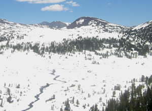
The 400-mile-long mountain range on California’s eastern border is by far the state’s largest water-storage facility. More than half of California’s water comes from snow in the Sierra Nevada. But unlike manmade reservoirs, frozen mountain water is difficult to measure and track through the year. Harsh winter conditions make survey missions to remote parts of the range expensive and treacherous. And convoluted topography and complex snowfall, thaw, absorption, and runoff regimens make calculating the amount of water stored there an exercise in extreme approximation, according to Roger Bales, professor of engineering at UC Merced and director of the Sierra Nevada Research Institute.
Even as the mountains start releasing their melting water in the spring, there is currently no way to know how much water they hold. This information gap has long posed a major challenge for state water managers: how to allocate a super-valuable resource when they are uncertain about how much they have or how far it will last into the dry summer months.
There are many stakeholders—municipal water district managers, farmers, hydro-power generators, wildlife resource managers, and industrial planners. Without reliable estimates, they have to assume worst-case scenarios, which often means being overly conservative. The opportunity costs can be profound. Farmers, for instance, could, in some years, plant a second crop round, but they seldom do; relying on water that may not be available could be disastrous.
Accelerating global warming and a growing population’s demand for water across the west intensifies the problems and raises the stakes. As the probability of bad droughts and floods increases, the value of accurate prediction—and the cost and danger of ignorance—grow, too.
To fill this information gap, a CITRIS-supported collaboration between Bales at UC Merced and Steven Glaser, a Berkeley professor in the department of civil and environmental engineering, deployed networks of wireless sensors in a prototype project at the National Science Foundation’s Southern Sierra Critical Zone Observatory (CZO), located in Providence Creek, south of Shaver Lake and about an hour west of Fresno. The sensors measure snow depth and other environmental factors that, once known, will allow much better measurement and prediction.
Before Bales recruited Glaser’s help, he lacked a reliable wireless system and was planning to hardwire sensors into networks connected by cable. But "it's hard to go several hundred meters with shielded cable,” says Glaser. "In the summer, bears like to tear it up, and rodents love to chew on it." It is also a lot more expensive to scale up and to repair when a connection is lost.
When Bales heard about Glaser's work with wireless networks back in 2007, he paid a visit to his Berkeley office. Glaser is known for pushing the cutting edge of wireless sensor networks and seeking new applications that can make a difference to society. And for Bales, integrating inexpensive sensors into remote wireless sensor networks (WSN) opened up a whole world of possibilities.
The CZO prototype project, which covers more than a square kilometer, is now logging data from 300 sensors—more soil-moisture, matric potential and snow-depth sensors than were located across the 400-mile-long mountain range 5 years ago. The CZO network also measures temperature, humidity, wind, and solar radiation. The match-book-sized sensors are paired with tiny, super-efficient, wireless communicating micro-processors known as motes— up to 100 motes in each WSN. The motes communicate with each other, aggregating data that are then delivered to computers at UC Merced and UC Berkeley.
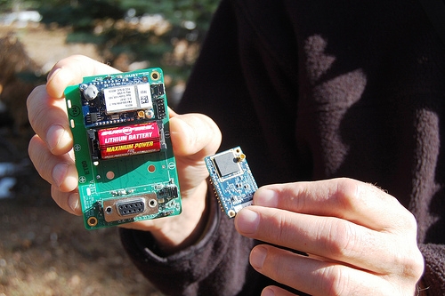
The tiny wireless technology that forms the foundation of this system (much of which was first developed by Kristofer Pister and David Culler at UC Berkeley, with the first applications of the technology by Glaser in 2000) is ultra-efficient and runs either on locally available power sources, such as solar, or on long-lasting and inexpensive batteries. The wireless network is self-repairing (if one node goes out, the others form a patch around it) and relatively inexpensive, says Branko Kerkez, an engineering graduate student of Glaser's and Bales's.
The network of sensors installed at the CZO allowed hydrologists on the project to experiment, along with the engineers, in deploying and adjusting the sensors as efficiently as possible. "We're trying to figure out how to optimally place sensors on a square kilometer area," says Kerkez. "It’s a recursive process. You place the sensors, collect the data, and then see if you need more or fewer sensors as you go." (Glaser and Kerkez are preparing a paper on sensor placement algorithms that will help others doing this kind of work in similar terrain.)
The next phase of the project involves instrumenting the American River basin, which covers about 4,500 square kilometers above Folsom Dam and is the source of a significant fraction of the state’s water. “We’re trying to establish about 25 instrument clusters. We have three built or in progress,” says Bales. “We'll have a network of local networks strategically placed to capture the geographical variability in the basin. Then we'll extrapolate all these water-cycle measurements for the whole basin.”
For snow estimation, the data will be combined with satellite data, which reveal the fraction of snow at 500-m spatial resolution. Says Bales, “The ground data tell you how deep the snow is, and the satellite data tell you where it is in the Sierra Nevada. You need to blend them.”
“Not only will the project provide high-resolution pictures of remote and icy watersheds, but will also allow water managers to build data-driven quantitative models that will have real predictive accuracy,” says Glaser.
“Today, water managers do statistical estimates of total seasonal runoff based on correlations with snow depth at a few index sites in each watershed. But this simple analysis of a very complex system yields results that are, in some years, just not very helpful in terms of prediction,” says Bales.
“You start with learning how much snow is there,” says Bales. “Then you measure rainfall, and estimate the timing of snowmelt, and measure how much water is used by trees and exits the system elsewhere.”
According to California Department of Food and Agriculture reports, farming here is a 35-billion dollar industry. “The benefits of better modeling could contribute to that total in several ways,” says Bales.
“Today, the water managers need to give conservative estimates on water availability,” says Bales. “They have to, given what they don’t know. If we reduce the uncertainty in their estimates in a way that people can use, we could pretty easily imagine adding a couple of hundred million dollars to the state’s economy.”